People like options. That is why auto companies successfully sell a variety of makes, in a range of colors. Even for those of us who will eventually choose a red Ford F150 pickup, we want to consider all of our options. The same thing is true about conservation. Farmers need options. They want to be able to choose the conservation practices that best meet their needs.
Minnesota passed a law in 2015 requiring farmers to install filters strips to improve water quality; that is, reduce sediment, phosphorous and nitrogen delivery to water bodies. To minimize the impact of taking land out of production, farmers will be allowed to install variable width filters or a combination of conservation practices, as long as they meet the primary goal of improving water quality. According to a Minnesota Board of Water & Soil Resources (BWSR) online publication, instead of requiring a 50 foot wide filter strip, it states that “a combination of practices… may be used to sufficiently meet water quality goals – and when that happens, a filter may not be needed.”
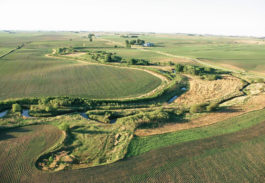
Traditionally, constant-width filter strips have been promoted by state and federal agencies. These filters are designed to handle water moving through the filter strip in a uniform flow. However, overland runoff is not uniformly distributed; it tends to concentrate within channels before reaching the stream. Therefore, a constant-width filter can become overwhelmed and would be only marginally effective. In fact, soil trapping efficiency is significantly reduced. Additionally, where low water flows exist, the standard 50 foot filter strip width may be overkill because there is very little water movement and sediment to trap.
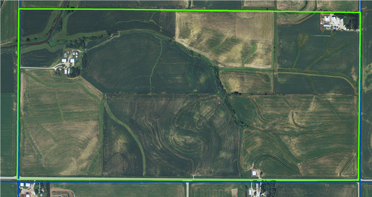
By Minnesota law, this stream will require a 50-foot wide filter strip, or equivalent, on both sides. A total of 10 acres will need to be converted from cropland for the filter strip (4,368’ X 50’/side x 2 sides = 436,800 sq ft/43,560 sq ft/acre = 10 acres).
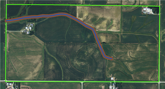
As I understand the Minnesota law, BWSR will be responsible for developing the rules to determine the combination of conservation practices farmers can use to meet water quality goals. The process used to determine alternative conservation practices will need to be transparent and science-based, as wildlife organizations will likely fight efforts to reduce acres going into grassland habitat. Furthermore, other activists may want to use the law to enforce stricter soil erosion standards. But, it is critical to maintain the integrity of the primary goal of the law — to improve water quality.
While installing constant-width filter strips can achieve some level of water quality improvement, the same improvement can be achieved by a number of other substitute mechanisms:
- Create variable width filter strips: vary the dimensions of the filter strip according to the amount of runoff and sediment delivery. The filter strip will be wider where runoff and sediment delivery is greater and narrower where runoff and sediment delivery is less. Using variable width filters, I estimate that farmers can achieve the same sediment load reduction, using 35 to 45% less grass (less land out of production).
- Impoundment structures: Build small impoundment structures (sediment basins) upstream in order to capture runoff and sediment before it reaches the stream. The impoundment will allow a narrower filter strip or even eliminate the need for a filter strip.
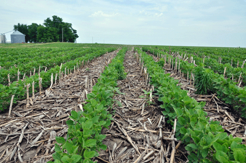
- Reduce soil erosion: Practices like no-till, contouring, terraces, and grassed waterways reduce sediment delivery to streams. These practices reduce in-field erosion and result in less sediment that needs to be filtered out.
The scientific methodology exists to effectively compare substitute practices against a standard, 50-foot wide filter. Models for that purpose have been developed and peer reviewed.
In order to determine the effectiveness of a 50 foot constant-width filter strip, three independent models will be required.
- The first model will focus on sheet and rill erosion (erosion that occurs on the hillslopes of agricultural fields). This model will determine where erosion occurs and where eroded soil is deposited while also accounting for different rotations and tillage systems.
- The second model will focus on ephemeral erosion, or channel erosion, and channel deposition. Much of eroded soil is deposited before it ever enters a water body. This model would account for the size of the watershed and different practices like sediment basins, terraces, and ponds, while modeling the amount of sediment transported to the filter strip.
- A third model must focus on the effectiveness of a filter strip in two different ways. First, it must determine the effectiveness of a 50-foot wide filter strip, based on the farming operations specific to each field. Then it must allow a farmer to adjust conservation practices and determine a filter strip arrangement that will meet the effectiveness of the 50 foot wide filter strip.
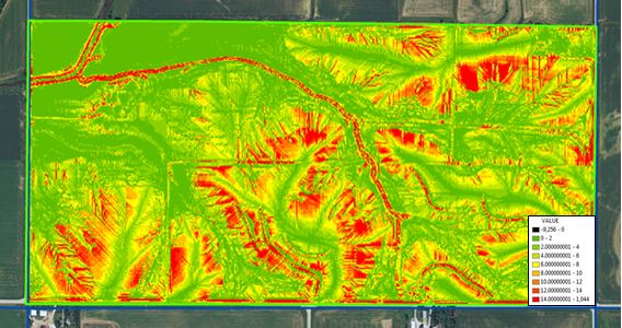
This soil erosion map, generated by Agren® SoilCalculator, shows the distribution and amount of sheet and rill erosion occurring in this field. Red indicates areas of high erosion and green indicates areas of low erosion.
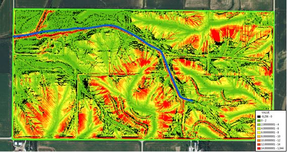
This soil erosion and deposition map is generated by Agren’s SoilCalculator. It is important to realize that some of the soil that has been eroded is re-deposited within the same field, as indicated by the black rasters. It is common for eroded soil to move downhill and be deposited in flatter areas of the field. Therefore, when designing filter strips, it is important to understand the difference between soil erosion and soil transportation.
Those areas that have high erosion (red areas) and are directly adjacent to the stream, have the most likelihood of delivering sediment to the stream.
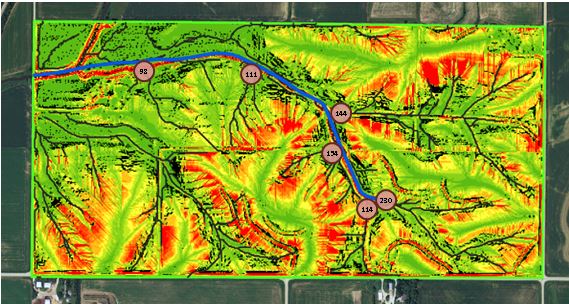
The “tons of soil transported to the stream” is calculated using a combination of Agren’s SoilCalculator and EphemeralGullyCalculator. Currently, these two models work independently, but over the next couple of months, Agren will integrate them into a seamless operation. The integration of these models provides the only known method whereby a non-technical person can calculate sediment delivery to a water body. Other methods are available, but they require extensive time and an expert modeler.
The erosion depicted in this image is based on a corn-soybean rotation; the corn is no-tilled in soybean residue and corn stalks are fall chiseled followed by spring field cultivation before planting soybeans. This example serves as a baseline for the next three options.
Option #1: Create variable width filter strips
Variable width filters are designed to be wider in areas where water and sediment are running into the stream in a concentrated flow or channel. The filter width is increased in these areas, while at the same time reduced in areas of non-concentrated flow. This reallocation of grass results in less total acres of filter strips required; as much as 3.5 to 4 acres in this example.
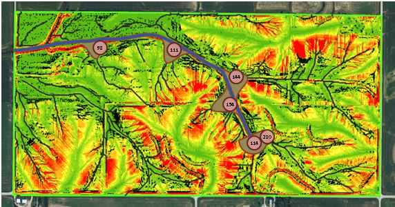
The variable width filters redistribute the grass in order to provide extra filtering capacity in areas of concentrated flow. The filter strip is widest where concentrated flow is delivering sediment to the stream, but only 16.5 feet wide in areas of non-concentrated flows.
Option #2: Impoundment structures
Impoundment structures include conservation practices such as a water and sediment control basin. A water and sediment control basin is a short earthen dam built across a drainage way. It traps water and sediment running off cropland, upslope from the structure, and reduces ephemeral gully erosion downslope by controlling flow within the drainage area. The basin releases water slowly, usually through infiltration or a pipe inlet and tile line. Basins are effective in reducing sediment in downstream waters.
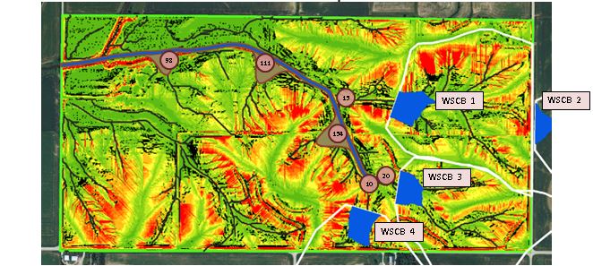
Agren® BasinBuilder was used to plan the four basins (WSCBs) displayed. These basins will temporarily store the runoff so that sediment can settle out, in the sediment basins. Together, these four basins will cost approximately $35,000 to install, but will save 4 to 5 acres of cropland that otherwise would need to be converted to filter strips. These basins are permanent structures and provide other tangible benefits, such as flood control and reduced need for grassed waterways. After a rainfall event, the water stored in the basin will drain (within 24 hours) into a surface intake and then through subsurface tile line, preventing crop damage. Sediment basins remove very little land from crop production.
In areas of concentrated flow where sediment basins are not installed, wider filters should be used to reduce sediment loads.
The reduction in sediment delivery due to the installation of sediment basins and the resulting variable width filter is only estimated. Agren currently has not integrated a filter strip design tool into its software.
Option #3: Reduce soil erosion
The third option for reducing the filter width is to reduce the amount of sediment delivered to the filter strip, thereby requiring a narrower filter strip to achieve the same water quality results. Reducing the amount of sediment delivered to a filter strip can be accomplished with a multitude of practices such as no-till, reduced tillage, contours, terraces, grassed waterways and cover crops.
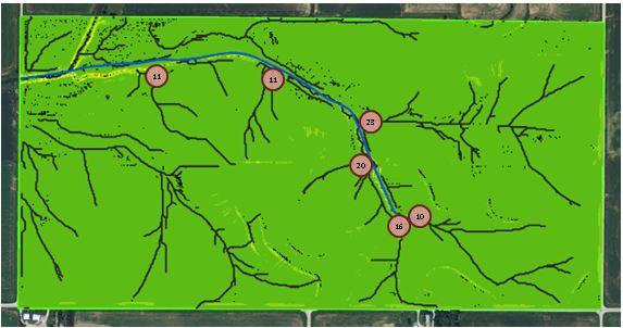
On average, sediment delivery in Option 3 is reduced 9 times over the management system in Option 1. Instead of 851 tons being delivered, only 91 tons are delivered to the stream. To achieve the same water quality benefits, this option would allow for a narrower filter strip or possibly allow the farmer to eliminate the filter strip. At the same time, this system would do more for sediment erosion reduction and soil health. As states mandate water quality actions, it is critical farmers are allowed to select from a list of conservation practices, rather than mandating “cookie cutter conservation.” All farmers have different operations and different management skills. As long as farmers achieve water quality standards, the farmer is in the best position to select the practices that best fit their operation. This is what we all desire – options and choices.
References:
| The application of the Revised Universal Soil Loss Equation, Version 2, to evaluate the impacts of alternative climate change scenarios on runoff and sediment yield – (Peer Reviewed Journal) |
| Dabney, S.M., Yoder, D.C., Vieira, D.A. 2012. The application of the Revised Universal Soil Loss Equation, Version 2, to evaluate the impacts of alternative climate change scenarios on runoff and sediment yield. Journal of Soil and Water Conservation. 67(5):343-353. |
| Spatially distributed sheet, rill, and ephemeral gully erosion – (Peer Reviewed Journal) |
| Dabney, S.M., Vieira, D.A., Yoder, D.C., Langendoen, E.J., Wells, R.R., Ursic, M.E. 2014. Spatially distributed sheet, rill, and ephemeral gully erosion. Journal Hydrologic Engineering. pp. C4014009-1-C4014009-12. |
| Effects of topographic feedback on erosion and deposition prediction – (Peer Reviewed Journal) |
| Dabney, S.M., Vieira, D.A., Yoder, D.C. 2013. Effects of topographic feedback on erosion and deposition prediction. Transactions of the ASABE. 56(2):727-736. |

 Good for Minnesota. They got it right!
Very nice, Tom.